About Tidal Atlas, Channel Islands & France
All sea maps from the Tidal Stream Atlas for the Channel Islands and Adjacent Coast of France. + Today's tide times for the reference station of these maps: Dover, including spring and neap tidal data, current moon data,...
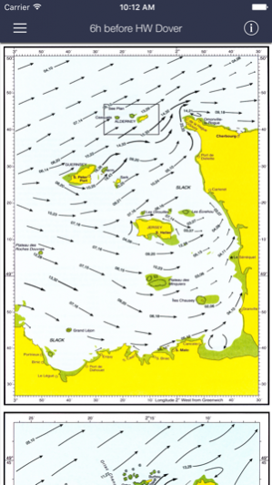
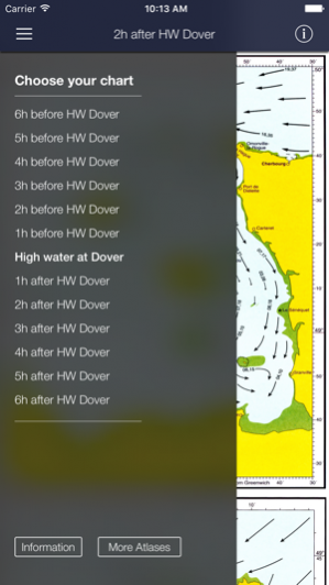
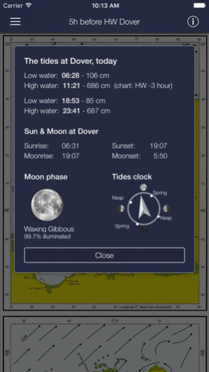
All sea maps from the Tidal Stream Atlas for the Channel Islands and Adjacent Coast of France. + Today's tide times for the reference station of these maps: Dover, including spring and neap tidal data, current moon data, sunrise and sunset. All 26 charts are available offline. The charts show both direction and rate of tidal streams at hourly intervals by careful and accurate use of graded arrows and display mean neap and spring tidal rates in tenths of a knot. The app also shows you today's tides at Dover, for which an internet connection is required. This app is universally available on both your iPhone and iPad. The sea maps are zoomable, thus also of good use on the smaller phone screen. This app is built and maintained by Surfcheck. All charts © Crown Copyright and/or database rights. Reproduced by permission of the Controller of Her Majesty’s Stationery Office and the UK Hydrographic Office (www.ukho.gov.uk). Disclaimer: We do our utmost to deliver you the best software and data available in the market, but of course we cannot guarantee the proper functioning or accuracy of both. Data sources can change over time. You can not derive rights from this information. By downloading and using this tidal stream atlas you accept these terms.
Apr 11, 2017 Version 2.0 V2.0 - Modernized code, some minor bug fixes in text and graphics.
Previous Versions
Here you can find the changelog of Tidal Atlas, Channel Islands & France since it was posted on our website on 2016-10-14 04:14:03.
The latest version is 2.0 and it was updated on 2024-03-27 22:22:50. See below the changes in each version.
Tidal Atlas, Channel Islands & France version 2.0
Updated At: 2017-04-11
Changes: 11 Apr 2017 Version 2.0
V2.0 - Modernized code, some minor bug fixes in text and graphics.
Tidal Atlas, Channel Islands & France version 2.0
Updated At: 2017-04-11
Changes: Apr 11, 2017 Version 2.0
V2.0 - Modernized code, some minor bug fixes in text and graphics.
Tidal Atlas, Channel Islands & France version 1.0
Updated At: 2016-09-20
Disclaimer
Official App Store Link
We do not host Tidal Atlas, Channel Islands & France on our servers. We did not scan it for viruses, adware, spyware or other type of malware. This app is hosted by Apple and passed their terms and conditions to be listed there. We recommend caution when installing it.
The App Store link for Tidal Atlas, Channel Islands & France is provided to you by apps112.com without any warranties, representations or guarantees of any kind, so access it at your own risk.
If you have questions regarding this particular app contact the publisher directly. For questions about the functionalities of apps112.com contact us.